Chinese scientists tailor farming methods to precious black soil
| 來(lái)源:Xinhua【字號(hào):大 中 小】

????Chinese scientists have developed tailored cultivation techniques and conservation measures for the black soil in the country's northeastern provinces to support food security and ecological safety, according to the Chinese Academy of Sciences (CAS). The black soil is sometimes referred to as the "giant panda of cultivated land" due to its fertility and scarcity.
????The black soil found in China's Heilongjiang, Jilin and Liaoning provinces and in some parts of the Inner Mongolia Autonomous Region covers a total area of 1.09 million square kilometers. It produces about a quarter of the country's total grain output. Hailed as the "stabilizer" and "ballast" of China's food production, it constitutes the country's most important commodity grain base.
????However, the black soil has experienced varying degrees of degradation due to factors such as excessive exploitation and climate change.
????CAS, together with relevant authorities in the four provincial-level regions, launched the "Black Soil Granary" program in 2021 to undertake research that would provide sci-tech support to combat the degradation of the precious soil and boost modern agricultural development.
????Seven technological demonstration zones have been established, covering a total area of 11,420 hectares. A total of 36 new soybean and corn varieties have been created and cultivated, and biotechnology to aid the rapid improvement of black soil fertility has been developed, according to CAS.
????BLACK SOIL HEALTH PROFILE
????The concentrated, contiguous arable land in the Sanjiang Plain, which includes the Heilongjiang, Songhua and Wusuli rivers, faces challenges that hinder an increase in production capacity, such as soil degradation, erosion and low temperatures, said Liu Huanjun, a researcher at the Northeast Institute of Geography and Agroecology (IGA), which is under the CAS.
????Additionally, a lack of spatiotemporal agricultural data hampers the improvement of intelligent farming practices. The extensive development of paddy fields has led to seasonal declines in groundwater levels and the spatiotemporal mismatch of water and soil resources.
????"A comprehensive solution that addresses these issues is urgently needed," Liu said.
????The plain has a humid environment and a large area of sloping cultivated land. The types and degrees of land degradation present are complex, as is the plain's natural geographical environment. Improper traditional farming practices have exacerbated soil erosion, resulting in the thinning and hardening of the topsoil, and soil fertility levels are also inconsistent. These problems cannot be solved using individual techniques or isolated approaches, Liu said.
????More than 100 scientists at the CAS have participated in research to develop an intelligent protection and utilization model for the plain's black soil, along with a systemic solution to these issues.
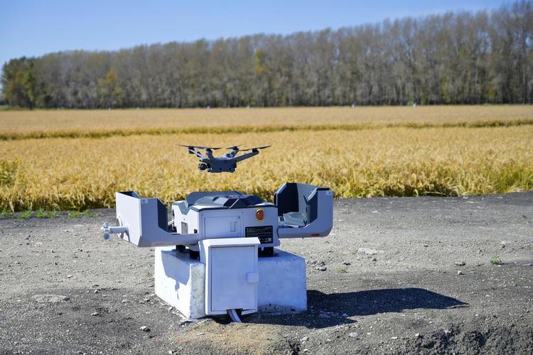
????The scientists developed a three-dimensional monitoring technique to observe the farmland, gathering data from 15 satellites, detectors on the ground, and aerial sensing using aircraft and drones.
????Three large-scale aerial remote sensing experiments have been carried out on the black soil, generating over 400 terabytes of data and aiming to quantitatively monitor the research area's soil, productivity, ecology and farmland degradation with meter-level precision, according to Liu.
????"We created a health profile for the black soil to get a clear picture of each piece of farmland, like reading palms," Liu said.
????PRECISE TREATMENT
????Based on the multi-dimensional and high-precision data, scientists have developed a comprehensive solution that can provide a systemic understanding of black soil, as well as precise diagnoses, prescriptions and technical treatment advice.
????Integrating remote sensing technology, satellite positioning systems, geographic information systems, the Internet of Things and artificial intelligence technologies, scientists have developed an intelligent management and control platform and app, which can be linked to intelligent agricultural machinery and equipment.
????Farmers can use the app to access various information services providing data on soil content, weather, crop growth, natural disasters and farmland yields, and to obtain precise agricultural production guidance in areas such as fertilization, pesticide spraying, sowing and irrigation.
????The app can also generate accurate fertilization maps based on multidimensional data on soil, crops and farmland quality at different growth stages, and send instructions to connected intelligent fertilization machinery to change amounts of fertilizer being applied, improve production efficiency and reduce pollution. In core demonstration areas, the application of fertilizers has decreased by 5 to 15 percent, and yields have increased by 5.48 to 14.2 percent.
????In response to the problem of water erosion on sloping farmland, scientists have carried out a series of precise "surgeries," changing the directions and widths of ridges to regulate water flows, planting grass between fields, and laying underground drainage pipes to divert water flows and prevent soil erosion.
????These measures have been introduced on nine farms, helping achieve grain production increases from 5 to 22 percent and a 70 percent reduction in soil erosion, according to IGA researcher Song Chunyu.
© 1996 - 中國(guó)科學(xué)院 版權(quán)所有
京ICP備05002857號(hào)-1 京公網(wǎng)安備110402500047號(hào) 網(wǎng)站標(biāo)識(shí)碼bm48000005
